"Here are Some Examples of Walks I Recommend"
Walk 1: ‘Ruta del Alcazar’
(4,5 km/app. 3 hours - level: easy )
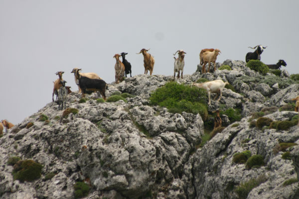
This pleasant stroll leaves from ‘The Alcázar’, the entrance of the 40.000 hectare Sierras de Tejeda Natural Park. We will follow the little stream ‘arroyo del alcázar’ after which we’ll walk a loop around the ‘loma de la víbora’ (viper’s hill). This is the northern flank of the Maroma Mountain, the highest mountain of the Axarquía region (2060 m). We will pass a number of interesting sites, such as the old fortification walls of the Moorish Alcázar, a castle fort, the ruins of a house where once resided a mythical family and of the old watch towers that were built along the old Andalucian ‘silk road’. During this walk you’re almost certain to see some of the beautiful ibex (cabras montes, or wild mountain goats) that graze on the greener pastures in the park.
(4,5 km/app. 3 hours - level: easy )
This pleasant stroll leaves from ‘The Alcázar’, the entrance of the 40.000 hectare Sierras de Tejeda Natural Park. We will follow the little stream ‘arroyo del alcázar’ after which we’ll walk a loop around the ‘loma de la víbora’ (viper’s hill). This is the northern flank of the Maroma Mountain, the highest mountain of the Axarquía region (2060 m). We will pass a number of interesting sites, such as the old fortification walls of the Moorish Alcázar, a castle fort, the ruins of a house where once resided a mythical family and of the old watch towers that were built along the old Andalucian ‘silk road’. During this walk you’re almost certain to see some of the beautiful ibex (cabras montes, or wild mountain goats) that graze on the greener pastures in the park.
Walk 2: ‘Meseta Zalia’
(5, 6 km/app. 4 hours - level: moderate.)
Zalia (also known as Tajo de la Mesa) is a remarkable table mountain southwest of the village of Alcaucín. Around 300 years BC, the seafaring Phoenicians founded a city on this mountain, from where they could still see the Mediterranean Sea and spot the casual pirate from far away. We start our walk on the eastern side of the meseta and enjoy these spectacular views on the Boquete de Zafarraya (the ‘gap’ in the mountain range that forms a natural barrier between the provinces of Málaga and Granada). We also see the little hamlet of Espino, and further on the looming mountain Maroma and the village of Alcaucín at its feet. We climb to the iron cross that was planted on this mountain during the Spanish Civil War. On this side of the mountain we can see Lake Viñuela, the village of Los Romanes, and the crows nest of the village Comares, the highest village of the Axarquía. On a clear day you can even see the Moroccan Rif Mountains! During our descent we pass by the hamlet of El Toril and the ruins of the old Phoenician fort that once protected the Phoenician city of Zalia..
Walk 3: ‘Las Majadas’
(7 km/app. 4,30 hours - level: easy to moderate)
Starting out from Alcaucin we walk up to the Chiringuito del Río, at the entrance of the nature park. Here we will descend via a goat path to the little hamlet of Las Majadas (a ‘majada’ is a corral where a shepherd would recollect his herd after the winter). We’ll have a look at the sulphur baths that were recently excavated before we continue our walk through the luscious oasis of Las Huertas, full of avocado, orange and olive trees. (‘las huertas’ literally means ‘the groves’). We will salute Santiago in his chapel hewn out of a solid rock and walk along the river and some centuries old mills back up through the villa’s of Macapa and back to Alcaucin.
Walk 4: ‘Nacimiento Río Bermuza’
(10 Km./app. 4 hours - level: easy to moderate)
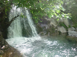
The walk starts again in the village of Alcaucín, at Plaza Fuente de Zalia. We’ll walk along the cementerio in the direction of Loma de Canillas, the hills that separate Alcaucín from the neighboring village of Canillas de Aceituno. Here we’ll take a walking path that follows the boundaries of the nature park until we arrive at a cave, the Cueva de la Fájara. This is where the Río Bermuza originates and there are some natural pools in which you can bathe - if there has been enough rainfall in the previous winter. We will continue our walk along to the old Molino de Enmedio, a now abandoned mill. This is the ideal spot for a picnic and to regain strength for the way back. We’ll take a higher pathway back that will give us some splendid views over the valley of Alcaucín.
Walk 5: City walk ‘Alháma de Granada’
(5 km/ appr. 4hours - level: easy) (This walk has a supplement of 15 Euros for the gasoline)
Option lunch-tapas bar ( The customer pays for the ‘ tapas’)
Alháma de Granada is what I would call an unknown treasure. We even suspect that well-known touristic guidebooks like Lonely Planet purposely restrain from writing too much about this picturesque town halfway between Málaga and Granada in order to avoid it becoming overly crowded with tourists! The name Alháma is derived from the Arabic name ‘Al hammam’, which means the bath or spring. Alháma is a thermal town and the healing waters of the natural hot springs have attracted visitors to this place for centuries. Just like the more touristic town of Ronda, the town of Alháma is divided by a spectacular gap (tajo), which will be the amazing setting for our walk. But we will also explore the impressive medieval part of the town and of course will visit the hot springs (bring your swimsuits!)